A Citizen's Proposal · April 2026
One Canada: Natural Boundaries, Equal Representation, One Country
This page presents the author's personal proposal to replace Canada's 10 provinces and 3 territories with 10 natural administrative regions based on watersheds, mountain ranges, and ecozones — boundaries that existed long before Confederation. The author argues that Canada's current provincial structure generates democratic inequality, economic inefficiency, and endless intergovernmental conflict.
The proposal matters because, in the author's view, Canada's constitutional design — unchanged at its core since 1867 — is holding the country back. Interprovincial trade barriers alone may cost Canada between $50 billion and $130 billion per year in lost economic output. A voter in Prince Edward Island currently has 2.8 times the federal representation of a voter in suburban Calgary. The author believes these are not minor inconveniences; they are structural failures.
The author does not expect this change in his lifetime, but writes for Canadians of future generations who may decide the country deserves better than a patched 19th-century framework. If this proposal interests you, the next step is to write your Member of Parliament. A ready-to-copy letter is available on Page 2.
A ready-to-copy letter for your MP is waiting on the next page.
Click here for a ready-to-copy letter you can send to your MP →
Preamble — The Author's Voice
Why This Page Exists
The author is a 70-year-old retired Canadian — a former soldier and UN peacekeeper, a financial professional, a technologist, a father and husband. He writes with no political party, no lobby group, and no agenda beyond a single conviction: Canada can be better than this.
For 157 years, Canada has governed itself using boundaries drawn by colonial negotiators, railway lobbyists, and constitutional compromises that made sense in the 1860s. The author argues that those boundaries now generate more friction than unity — equalization fights, healthcare jurisdiction battles, and interprovincial trade barriers that make it harder to ship beer from New Brunswick to Ontario than from New Brunswick to Belgium.
The central question this page asks is simple: What if we started over? Not with anger, not with revolution — but with common sense, applied to the geography and demographics of the country as it actually exists today, for the benefit of generations yet to come.
"We are not a country of ten provinces. We are a country of thirty-seven million people." — The common-sense principle this proposal is built on
Historical Context
Why Previous Attempts Failed
The author acknowledges directly that fundamental constitutional reform in Canada has an almost unbroken record of failure. The Meech Lake Accord (1987–1990) and the Charlottetown Accord (1992) — the two most serious efforts at constitutional renewal since 1982 — both collapsed. The author's view is that understanding why they failed is essential to understanding what would need to be different.
The amending formula sets an extraordinarily high bar
Under Section 38 of the Constitution Act, 1982, major constitutional amendments require approval by Parliament plus seven provinces representing at least 50% of the population. Some changes — including abolishing the Senate — require the unanimous consent of all provinces under Section 41. The author notes bluntly: "difficult is not the same as impossible, and unprecedented is not the same as wrong." But the bar is real, and past reform efforts failed precisely because they could not clear it.
Provincial governments have a structural interest in their own survival
The author argues that the provincial governments most resistant to change are the ones with the most to lose. Each province's political class — its premiers, ministers, civil servants, and party machinery — has a direct personal and institutional interest in preserving the system that employs and empowers them. This is not malice; it is the rational behaviour of any institution defending its own existence. But it creates a structural bias against reform that goes beyond any particular policy disagreement.
Interprovincial resentments entrench the status quo
The equalization formula has created a dynamic where any proposal for reform is immediately filtered through the lens of regional self-interest. Alberta and British Columbia suspect any change will cost them money. Smaller provinces suspect any change will cost them seats and influence. In the author's view, this makes even sensible, well-reasoned proposals politically toxic before the conversation begins. The architecture of suspicion is itself one of the problems the proposal attempts to dissolve.
The timing of past efforts was wrong
Meech Lake was negotiated by eleven men in a room, without public participation, and was seen by many Canadians — particularly Indigenous peoples, women, and residents of territories — as a deal that excluded them entirely. Charlottetown went to a referendum and was rejected by majorities in six provinces. The author draws no explicit blueprint for how reform should be pursued, but implicitly suggests that any future effort would need to be built from the ground up, through genuine public deliberation, rather than imposed from the top.
The Author's Central Argument
Why Canada Risks Never Reaching Its Potential
The author's deepest concern is not that Canada is failing — it is that Canada is dramatically underperforming relative to what it could be. The country holds extraordinary cards: the second-largest landmass on Earth, the world's longest coastline, immense reserves of fresh water, fossil fuels, critical minerals, arable land, hydroelectric potential, and a highly educated, diverse, multicultural population. In the author's view, the structure of the country's government is squandering these advantages.
The cost of fragmentation is measurable
The C.D. Howe Institute has estimated that interprovincial trade barriers cost Canada between $50 billion and $130 billion per year in lost economic output. The International Monetary Fund has described Canada's internal market as one of the most fragmented among advanced economies. A licensed electrician in British Columbia must re-certify to work in Alberta. A nurse trained in Ontario cannot simply practice in Quebec. The author argues these are not minor regulatory inconveniences — they are structural losses compounded over decades.
Democratic inequality is a moral failure, not just a technical one
A voter in Prince Edward Island currently has 2.8 times the federal representation of a voter in suburban Calgary — not because of any difference in citizenship, but because of a constitutional clause from 1867 and a grandfather clause from 1985. The author frames this not merely as an inefficiency, but as a fundamental breach of the democratic promise made to every Canadian at birth. Equal citizenship should mean equal representation.
The North is being left behind
Canada's northern territories — covering millions of square kilometres — are governed by arrangements where territorial powers are delegated by Parliament rather than constitutionally guaranteed. The author argues that a unified Canada would have both the obligation and the incentive to invest in northern infrastructure, governance, and services in ways the current system does not. The Arctic is not a distant abstraction; it is the frontier on which Canada's sovereignty and resource future depend.
The status quo is not stable
The author is explicit that the structural problems he identifies are not static. Climate change is reshaping the North. Canada's population centre is drifting westward. The fiscal pressures of an aging population will intensify the equalization argument. Each decade of inaction makes the eventual reckoning larger. The choice, as the author frames it, is not between change and stability — it is between deliberate, principled change now and disorderly, reactive change later.
"At some point, Canadians will have to choose: do we keep patching a 19th-century framework with 21st-century duct tape, or do we build something worthy of the country this actually is?" — Ted Lee
Part I — The Problem
A Country Divided by History, Not Logic
Unequal representation
Canada's 343 federal ridings are not equal. The Constitution Act's senatorial clause guarantees every province at least as many MPs as it has senators. The grandfather clause ensures no province ever loses seats, even as its population declines. The result: a voter in Prince Edward Island has roughly 2.8 times the federal representation of a voter in suburban Calgary. PEI's 160,000 people receive 4 MPs — one per 40,000 people. Alberta's 4.6 million receive 37 MPs — one per 124,000 people. The author calls this not an accident, but a deliberate constitutional design from 1867, preserved through every redistribution since.
Interprovincial trade barriers
The Canadian Free Trade Agreement (CFTA) of 2017 was supposed to create a single internal market. According to the author, it has not. Provincial regulations still create what the International Monetary Fund described as "one of the most balkanized internal markets among advanced economies." Workers cannot freely move credentials across provincial borders. A licensed electrician in British Columbia must re-certify to work in Alberta. A nurse trained in Ontario cannot simply practice in Quebec. The author estimates these barriers cost 3–4% of GDP annually.
Duplicated bureaucracy
Canada operates 14 separate healthcare systems (10 provincial, 3 territorial, plus federal for veterans and Indigenous peoples). Fourteen separate education ministries. Fourteen separate sets of securities regulations — Canada remains the only G7 country without a national securities regulator. Each province maintains its own tax collection system alongside the federal CRA. The author argues this duplication costs billions and produces inconsistent outcomes for citizens depending entirely on which side of an invisible line they happen to live on.
The equalization trap
Section 36(2) of the Constitution Act, 1982, commits the federal government to equalization payments ensuring comparable service levels across provinces. The author argues that in principle this is solidarity; in practice it has become the single most divisive issue in Confederation. Alberta and BC resent funding provinces that block pipelines carrying the resources that generate the equalization revenue. Recipient provinces resent being characterized as dependents. The formula is opaque and politically manipulated. The author's view is that the argument never ends because the structure guarantees it cannot.
Part II — The Solution
Natural Boundaries and Equal Ridings
The author's proposal replaces the 10 provinces and 3 territories with 10 natural administrative regions defined by watersheds, mountain ranges, ecozones, and geological formations — features that existed before any European drew a line on a map. These regions are administrative, not sovereign. They do not have premiers. They do not negotiate with Ottawa. They administer local services under national standards.
What gets abolished
| Abolished | Why the Author Argues It Should Go |
|---|---|
| 10 provinces, 3 territories | Replaced by 10 natural regions (administrative, not sovereign) |
| The Senate | An unelected chamber based on 1867 regional horse-trading. Replaced by equal-population democratic representation |
| Senatorial clause | No province should get seats based on a senator count from 1915 |
| Grandfather clause | No region should keep seats it no longer has the population to justify |
| Equalization formula | One national government = one national revenue pool = no transfers to fight over |
| Interprovincial trade barriers | No provinces = no interprovincial barriers. One market. One country. |
| 14 duplicated bureaucracies | One national healthcare system. One education standard. One securities regulator. |
What gets created
| Created | Why the Author Argues It Should Exist |
|---|---|
| 10 natural regions | Administrative districts defined by watersheds, mountains, and ecozones — not colonial history |
| 343 equal-population ridings | Every riding = ~107,700 people. One person, one vote, truly equal |
| Single national assembly | One democratic chamber. No Senate veto. No competing provincial mandates |
| New purpose-built capital | A capital chosen by geography and population, not by Queen Victoria in 1857 |
| Unified national services | One healthcare system, one education framework, one securities regulator, one professional credential |
| Indigenous governance framework | Direct nation-to-nation relationship with the national government, not fragmented across 14 jurisdictions |
Part III — The 10 Natural Regions
Canada Redivided by Nature
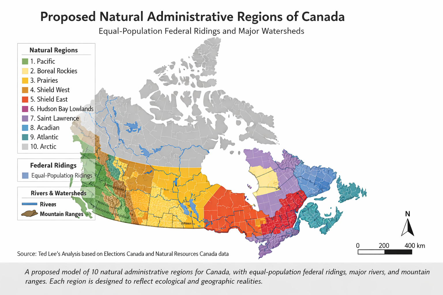
Canada reimagined as 10 natural administrative regions defined by watersheds, mountain ranges, and ecozones — not colonial history. Under this model, 341 of 343 federal ridings fall within ±5% of the equal-population target of 107,847.
Data: Elections Canada 2023 Representation Order • Natural Earth • Statistics Canada 2021 Census • Albers Equal Area Conic Projection
Each region is defined by where water flows, where mountains rise, and where ecosystems change. The author argues these boundaries have been stable for millennia and will outlast any equalization cheque.
1. Pacific Maritime
Everything west of the Coast Range to the Pacific Ocean. Vancouver metro, Victoria, the Islands, the Sunshine Coast. Defined by the Fraser River watershed and temperate rainforest ecozone. Canada's Pacific gateway.
2. Cordillera Interior
Between the Coast Range and the Rocky Mountains. The dry interior plateau, the Columbia Basin, the Kootenays. Kamloops, Kelowna, Prince George. Mining, ranching, forestry — a mountain economy distinct from the coast.
3. Prairie Grasslands
From the Rocky Mountain foothills to the Canadian Shield edge. The Saskatchewan River watershed, draining to Hudson Bay. Calgary, Edmonton, Saskatoon, Regina. Energy, agriculture, and continental climate. The author argues this is one connected grassland — not three separate provinces.
4. Northern Shield
The subarctic mainland. Mackenzie River watershed, taiga Shield, permafrost. Yellowknife, Whitehorse. Vast geography, sparse population, Indigenous governance. One seat — but a seat representing an area larger than Western Europe.
5. Arctic Archipelago
The Arctic islands. Polar desert, Inuit Nunangat, ice-dependent ecosystems. Iqaluit, Rankin Inlet, Cambridge Bay. The author notes this is the one exception to pure population math — geography and Indigenous sovereignty require guaranteed representation.
6. Hudson Bay Lowlands
Everything draining into Hudson Bay south of the treeline. The Nelson-Churchill river system, boreal muskeg, Manitoba's east and northwestern Ontario. Winnipeg anchors the population. Hydroelectric power defines the economy.
7. Great Lakes – St. Lawrence
The population heartland. The narrow glacial lowland between the Canadian Shield and the Great Lakes, running from Windsor to Quebec City. Toronto, Montreal, Ottawa, Hamilton, Quebec City. 49% of Canada's population in one geological corridor. The author is direct: this is democracy — the most people get the most seats.
8. Laurentian Highlands
The Precambrian Shield plateau of northern Quebec and Labrador. Boreal forest, thousands of lakes, James Bay and Churchill Falls hydroelectric. Saguenay, Sept-Îles, Labrador City. The engine room that powers the corridor below.
9. Atlantic Maritime
Appalachian geology, maritime climate, Bay of Fundy tidal systems. Halifax, Saint John, Moncton, Charlottetown. The sea defines everything here — fishing, shipping, tides. The author argues this is one coherent maritime region, not three small provinces protected by a clause from 1915.
10. Newfoundland Coast
The island of Newfoundland, isolated by the Cabot Strait. Subarctic coastal barrens, Grand Banks marine zone, outport culture. St. John's, Corner Brook, Gander. The author notes that island biogeography makes this a natural region — the strait is the boundary nature drew.
Part IV — A New Capital
Governing From Where Canada Actually Is
Ottawa was chosen as Canada's capital in 1857 by Queen Victoria — largely because it was far enough from the American border to be defensible, and its position on the Ontario-Quebec boundary made it a compromise between English and French Canada. The author argues these are not 21st-century criteria for governing a country of 37 million people stretching from the Pacific to the Atlantic to the Arctic.
Option 1: Geographic Centre
Location: Near Baker Lake, Nunavut (62.4°N, 96.5°W). The literal middle of Canada as calculated by Natural Resources Canada. The case for: Symbolically extraordinary — governing from the heart of the land, on Inuit territory, signalling a fundamental rebalancing of the relationship with Indigenous peoples. The Brasília model: bold, visionary, purposeful. The case against: Permafrost. −33°C average winter temperatures. No road access. No existing infrastructure. Staggeringly expensive.
Option 2 (Recommended by the author): Population Centre
Location: Near Sharbot Lake / Bancroft, eastern Ontario (~44.8°N, 76.7°W). The population-weighted balance point of Canada — currently drifting westward as western Canada grows. The case for: Equidistant in people-distance from all Canadians. Near existing rail and highway corridors. Crucially, not Toronto, not Montreal, not Ottawa — a fresh start on Shield bedrock. The author calls this the Canberra model: Australia chose a site between Sydney and Melbourne specifically to end the rivalry. Canada should do the same between Toronto and Montreal. The case against: Still in the Great Lakes–St. Lawrence corridor, which western and Atlantic Canadians may perceive as continued central Canadian dominance.
Part V — Why This Makes Canada Stronger
Eight Benefits the Author Argues Would Follow
-
1
Democratic equality
Every Canadian's vote carries equal weight. No constitutional clauses making one citizen's representation worth 2.8 times another's. Every riding: ~107,700 people. No exceptions.
-
2
Economic efficiency
Eliminating 14 overlapping bureaucracies and creating unified national systems for healthcare, education, securities regulation, and professional licensing would save billions annually. Interprovincial trade barriers alone cost Canada up to $130 billion per year in lost output.
-
3
End the equalization war
No provinces means no equalization transfers. One national government collects revenue nationally and allocates services nationally. The corrosive argument about which province subsidizes which other disappears — because provinces no longer exist.
-
4
Labour mobility
A nurse trained anywhere in Canada works anywhere in Canada. An electrician, teacher, or lawyer — one credential, one country. The labour market becomes truly national, and workers move to where they are needed most.
-
5
Stronger on the world stage
Canada currently negotiates international trade deals while its own internal market is more fragmented than the European Union's. A unified Canada speaks with one voice internationally.
-
6
Better for Indigenous peoples
The current system fragments Indigenous governance across 14 jurisdictions. A unified Canada enables a single, direct nation-to-nation relationship — eliminating jurisdictional gaps that currently leave Indigenous communities underserved by both levels of government simultaneously.
-
7
Better climate and resource management
Watersheds do not respect provincial boundaries. Managing water, forests, fisheries, and carbon emissions by natural watershed boundaries rather than political ones produces better ecological outcomes.
-
8
National unity
The deepest benefit: Canadians would stop identifying primarily as Albertans or Ontarians or Quebecers. Provincial identity is not innate — it is constructed and reinforced by provincial governments. Remove the structure, and what remains is what Canadians share: the land, the Charter, the commitment to a society that takes care of its people.
Part VI — Addressing the Hard Questions
The Author's Answers to the Toughest Objections
What about Quebec?
The author addresses this directly and carefully. French-Canadian culture is not merely a provincial concern — it is a founding pillar of the country. In a unified Canada, Francophone rights would be constitutionally entrenched at the national level, not dependent on provincial political power. The author argues that the assumption that French-Canadian culture can only survive through provincial sovereignty assumes the national government is hostile to it. "In a unified Canada, there is no 'hostile' level — there is only one government, and Francophones are a major constituency within it."
What about the North?
The Arctic Archipelago and Northern Shield regions would each receive guaranteed representation regardless of population — the one departure from pure population math. Northern and Arctic residents would also benefit from a national government dealing with them directly, rather than the current territorial arrangement where territories' powers are delegated by Parliament, not constitutionally guaranteed.
Is this even legally possible?
The author is honest about this. Constitutional amendment under Section 38 requires Parliament plus seven provinces representing at least 50% of the population. Some changes require unanimous consent under Section 41. The Meech Lake and Charlottetown Accords both failed. But, the author argues, "difficult is not the same as impossible, and unprecedented is not the same as wrong." The question is not whether it can be done, but whether future generations will decide it should be.
Wouldn't the Great Lakes region dominate everything?
Yes — and the author says that is democracy. The Great Lakes–St. Lawrence corridor holds 49% of Canada's population and would hold 49% of the seats. The current system artificially dilutes the representation of 18 million people through senatorial and grandfather clauses. The check on regional dominance is the Charter of Rights and Freedoms, not rigged arithmetic.
Part VIII — For Future Generations
A Message to the Canada of 2066
The author does not expect this to happen in his lifetime. Constitutional reform in Canada is glacial — literally harder than amending some countries' constitutions. But he writes for the 25-year-old Canadian in 2026 who will be 65 in 2066 — the bicentennial of Confederation. By then, Canada's population may be 55 million. Climate change will have reshaped the North. The equalization formula will have generated another four decades of interprovincial rancour.
The author's closing argument: the land already has its boundaries. The rivers already flow. The mountains already stand. The only missing element is the political courage to govern accordingly.
"The reasonable man adapts himself to the world; the unreasonable one persists in trying to adapt the world to himself. Therefore all progress depends on the unreasonable man." — George Bernard Shaw
Part VII — Sources & References
Sources the Author Relies On
Constitutional framework
- Constitution Act, 1867 — Section 51 (seat distribution), Section 22 (Senate regional divisions). The structural foundations this proposal would replace.
- Constitution Act, 1982 — Part V (Sections 38–49, amending formula), Section 36(2) (equalization commitment), Section 41 (unanimous consent matters).
- Canadian Charter of Rights and Freedoms — Sections 16–23 (language rights), Section 3 (right to vote), Section 15 (equality).
Representation & redistribution
- Representation Act, 1985 — Introduced the grandfather clause. Updated 2022 by the Preserving Provincial Representation in the House of Commons Act (Bill C-14), restoring Quebec's seat count to 78.
- 2023 Representation Order — Current federal electoral map, proclaimed September 22, 2023, increasing seats from 338 to 343. Based on 2021 Census data. First applied in the 2025 federal election.
- Elections Canada — House of Commons Seat Allocation: elections.ca/content.aspx?section=res&dir=cir/red/allo
Economic analysis
- C.D. Howe Institute — Multiple studies on interprovincial trade barriers, including "Missed Connections" (2019) estimating GDP losses.
- International Monetary Fund — Article IV consultations on Canada repeatedly citing internal trade barriers as a structural drag on growth.
- Senate of Canada Standing Committee on Banking, Trade and Commerce — "Tear Down These Walls" (2016), a comprehensive report on interprovincial barriers.
Geographic & ecological foundations
- Natural Resources Canada — Atlas of Canada — Geographic centre of Canada at 62°24'N, 96°28'W (near Yathkyed Lake, Nunavut).
- Environment and Climate Change Canada — Ecozones of Canada — 15 terrestrial ecozones that form the scientific basis for the natural regional boundaries proposed here.
- Natural Resources Canada — Watershed boundaries — Major drainage basins (Pacific, Arctic, Hudson Bay, Atlantic, Gulf of Mexico).
Purpose-built capitals — international precedents
- Canberra, Australia (1913) — Built to resolve the Sydney–Melbourne rivalry. The most directly analogous precedent for Canada.
- Brasília, Brazil (1960) — Moved the capital from coastal Rio de Janeiro to the interior to promote national integration.
- Astana (now Nur-Sultan), Kazakhstan (1997) — Moved from Almaty to a central location to promote national unity.
Write to your MP, your MLA or MPP, your Premier, or the Prime Minister.
A complete ready-to-copy letter is on the next page.
Click here for a ready-to-copy letter you can send to your MP →